|
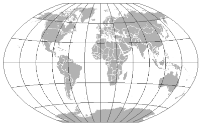
| The Winkle triple world map projection, credit to ESRI |
What's a map projection you ask? Well essentially it's the different ways in which we can decide to flatten the spherical earth to be a flat map, suitable for viewing on a piece of paper or on a computer screen. There are different projections available as you just can't flatten something that's spherical without 'breaking' it or warping it. Try it with an orange... carefully peel it so it stays in one segment.. now try and flatten it on the table without applying very much pressure. You can't do it. One bit of it always stick up doesn't it. Well that's essentially what map projections are about - as the way that we DO flatten the earth (or orange peel) means that we get distortion.
So anyway, here's an article about map projections from ESRI who know alot more about it than my trivial understanding! For those who don't know, ESRI are the people behind the GIS industry standard Arc software:
http://blogs.esri.com/Support/blogs/mappingcenter/archive/2011/02/17/an-alternative-to-web-mercator-winkle-triple.aspx
EDIT: Just coming back to this blog post, as the BBC have recently shown an excellent documentary about mapping which is very relevant!
LINK